
The DANA of 29 October 2024 was the costliest natural disaster in Spain's history: 229 fatalities in the province of Valencia (237 across the country, per the official toll), more than 82,000 households compensated and an insurance bill above 2.2 billion euros. A year on, the least visible consequence for anyone buying a home is this: the flood-zone maps are being redrawn, the mapped area will be larger than the one in force, and a plot that reads outside today can end up inside. Before signing a deposit contract in Valencia or l'Horta Sud, it is worth knowing which map your prospective home sits on.
What happened on 29 October 2024
Within hours, Spain's weather agency AEMET recorded 771.8 mm of rain in 24 hours in Turís (Valencia) and broke the national one-hour rainfall record with 184.6 mm. Flash floods in ravines such as the Rambla del Poyo —which peaked at around 2,400 m³/s according to the Júcar River Basin Authority (Confederación Hidrográfica del Júcar)— devastated the south of the metropolitan area: Paiporta, Catarroja, Alfafar, Sedaví, Massanassa, Benetússer, Picanya, Aldaia, Torrent, Algemesí, Utiel and Chiva are among the hardest-hit towns.
Spain's Insurance Compensation Consortium (Consorcio de Compensación de Seguros) has processed close to 80,000 claims relating to homes and homeowners' associations, 95% of them in the province of Valencia. More than 82,000 households have already been paid, with an outlay near 1.1 billion euros for the housing chapter alone; the total exceeds 2.2 billion euros, making the DANA the most expensive natural disaster ever covered by Spain's extraordinary-risk insurance system.
Why the flood-zone maps are changing
In several places, the water went beyond what the official cartography in force had predicted. That has triggered two parallel revisions. At national level, the Ministry for the Ecological Transition (MITECO) and the Júcar River Basin Authority are updating the flood hazard and risk maps of the National Flood Zone Mapping System (SNCZI) to fold in what the DANA revealed, within the third cycle of the Flood Risk Management Plan. At regional level, the Valencian Government has begun revising PATRICOVA —the plan that governs what can be built in a flood zone— in two phases: first the areas hit by the DANA, then the whole region. While the process runs, the regional government has even suspended planning procedures in flood zones that are already delimited.
The direction of travel is already clear: the area classed as floodable will be wider than today, and the restrictions on building or extending in those zones stricter. For a buyer, that means the risk picture of a plot can change between signing the deposit contract and completing the sale.
What it means if you are buying in an affected area
- Delimitation: a plot can fall inside the new flood zone even if it is outside the cartography in force today. Check both.
- Works: renovating, extending or building in a flood zone requires a favourable report from the river basin authority and may be conditioned or suspended during the revision.
- Insurance: the Consortium covers extraordinary flooding, but ask for the property's claims history and review the premiums, deductibles and exclusions of the current policy.
- Price and financing: the valuation and the bank weigh flood risk; a change of classification can affect the appraisal.
- Damage is not the map: a plot sitting in the 2024 footprint does not prove the building flooded or how much repairs cost. It is the list of questions for the seller, not a verdict.
How Hogarfax checks it
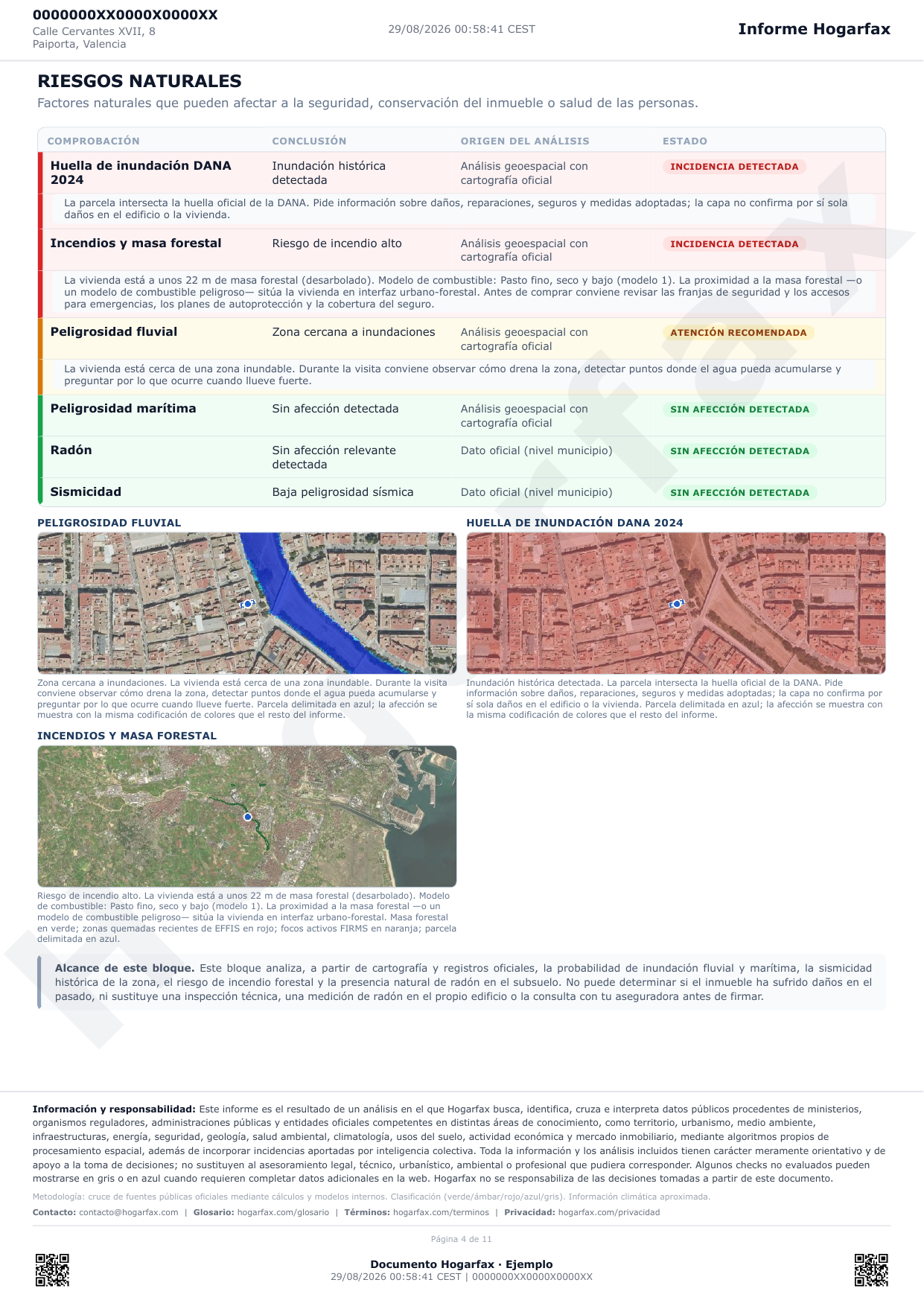
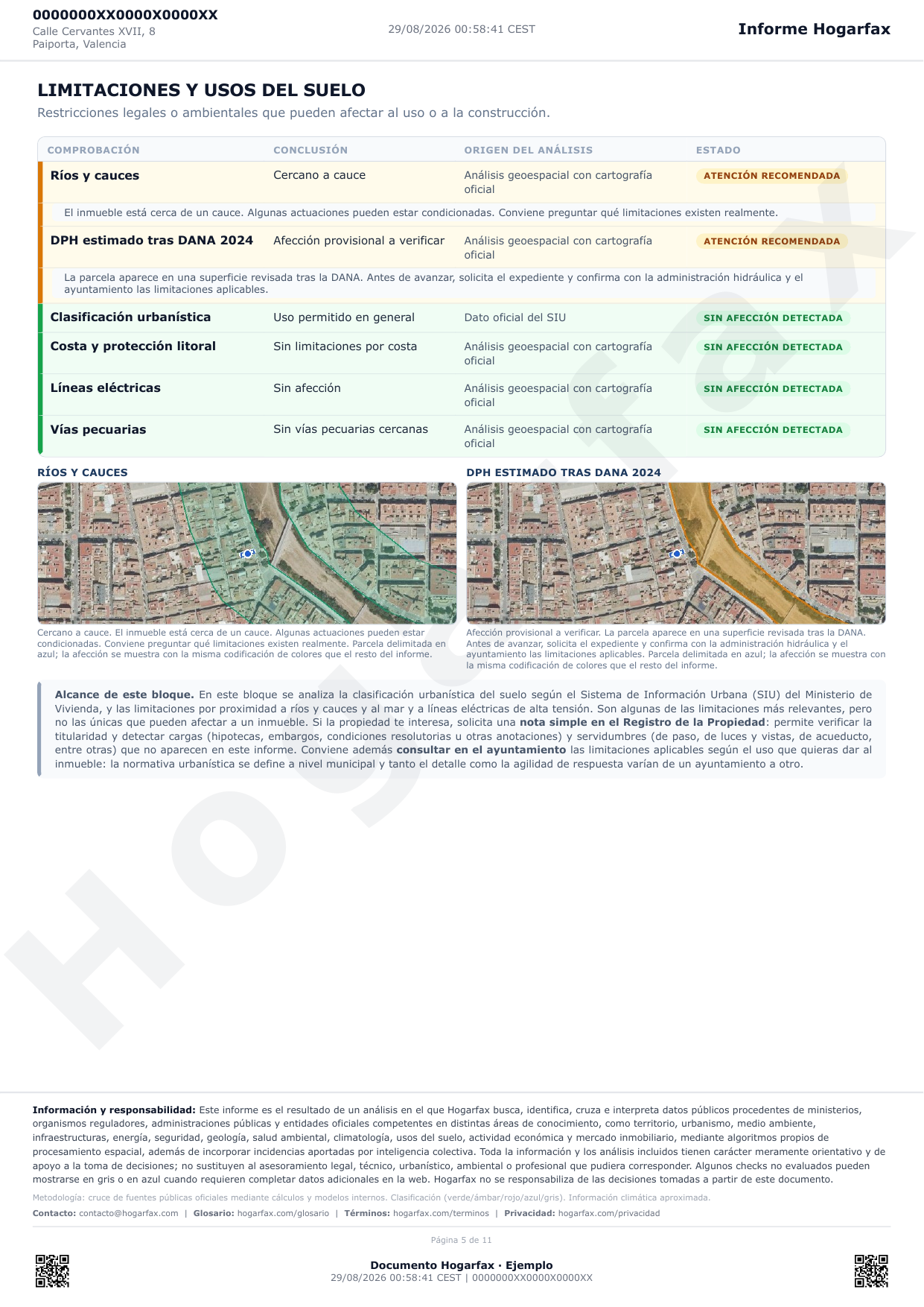
The Hogarfax report crosses the property's exact plot with the official footprint of the area that flooded during the DANA of 29 October 2024 and with the provisional watercourse delimitation revised after the event, and presents it separately from ordinary river flood hazard and from the mapped public water domain. We do not publish which internal layers build each signal or how they are combined —there is too much copying in this sector—; what you get is the outcome: whether the home you are looking at is flagged by any of these maps, with its official source and what to ask before signing.
That information, crossed with the rest of the report —river and coastal flood hazard, public water domain, seismic hazard, wildfire exposure, power lines, nearby industry—, is what turns a quick viewing into a decision backed by data. In the rainy and DANA season, it is a check that should not be missing before buying a home in eastern and southern Spain.
Check whether a home is in a flood zone
Enter the address or the cadastral reference and cross the 2024 DANA footprint, river flood hazard, the public water domain and the rest of the risks on the official map. For 24.90 €.
Analyse a propertyWas this article useful?
Your answer helps us improve the blog and understand which guides deserve more depth.