
The listing could have shown an ordinary home in Los Gallardos, Almería. A Hogarfax report generated on 13 July 2026 raised a much harder question: what does it mean to buy a home while the comarca is in the news because of a wildfire covering around 7,000 hectares? This anonymised case uses a residential property in the town. We do not publish the full street address or cadastral reference; we do show the evidence needed to understand the decision.
The context: the wildfire that put Los Gallardos in the headlines
The fire started on 9 July next to the N-340A and spread across Los Gallardos, Bédar and Lubrín. The evolution reported by EFE and the Andalusian Government describes a fire with fatalities, evacuations and around 7,000 hectares affected. By 13 July the emergency level had fallen and the perimeter was stabilised, but stabilised does not mean the land has returned to normal or that a nearby property no longer needs checking.
What the report found about this exact property
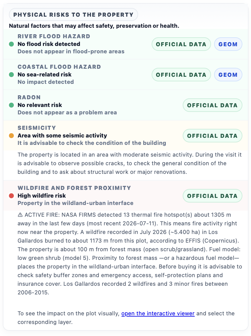
The physical-risk block marked “High wildfire risk” and placed the property in the wildland-urban interface. The detail showed three signals a listing rarely gives you: 13 active NASA FIRMS thermal hotspots about 1,305 metres away, a July 2026 fire with an approximately 5,400-hectare perimeter according to EFFIS about 1,173 metres away, and forest mass about 100 metres from the property. The report also retained the earlier municipal history: 2 fires and 3 minor fires between 2006 and 2015. Low historical frequency did not cancel the current signal.
That is what makes this case powerful: it does not simply say “Los Gallardos is risky”. It says what was visible from this property on the report date. The difference between 1,305 metres, 1,173 metres and 100 metres matters for access, smoke, evacuation, fuel continuity, insurance and recovery. The national active fires map follows the live situation; the wildfire risk map explains the wider context; and the report brings both layers down to the exact plot.
The amber warning: moderate seismicity is not a diagnosis
The same report showed “Area with some seismic activity”, with a recommendation to review the building's condition. This is a location-context signal based on the area's seismic classification; it does not claim the house is damaged, identify a crack or replace a structural inspection. It does change the viewing questions: are there new or repaired cracks, what structural work has been done, is there building documentation, and should a professional inspect it? Our guide to earthquake risk when buying property in Spain explains how to read this signal without alarmism.
The news and the report tell two parts of the same story
- The news tells the emergency story: burnt area, evacuations, fatalities and operational updates.
- The live map shows where satellites detect heat and refreshes several times a day; a hotspot is a thermal detection, not a verdict about a home.
- The report measures the spatial relationship between the property and the layers: perimeter distance, active hotspots, forest mass and other factors.
- Seismicity adds a second question: wildfire is not the only context worth reviewing before you buy.
What to check before buying in an affected area
For a property like this, we would request the latest perimeter and access information, review safety buffers and insurance, check for smoke or heat damage and ask about the building's condition. We would also separate what the data proves from what still needs a professional: a satellite layer locates exposure; it does not certify habitability, structural damage or the cause of a fire.
Read the Los Gallardos wildfire satellite-data analysis, check active fires now or read the guide to buying property near wildfire risk.
Check the exact property before you sign
Enter the address or cadastral reference and cross-check active fire, burnt perimeters, forest mass, seismicity and 25+ other factors on the exact plot. Full report for €24.90 (VAT included).
Analyse the propertyFuentes
efe.com/espana/2026-07-13/incendio-los-gallardos-almeria-evolucion/
www.juntadeandalucia.es/boja/2026/513/1
firms.modaps.eosdis.nasa.gov/
forest-fire.emergency.copernicus.eu/
Was this article useful?
Your answer helps us improve the blog and understand which guides deserve more depth.